glo.texas.gov
Facebook
Twitter
YouTube
Medium
Texas GLO
Map
Database and Store
Home
Search
Showcase
About
Facebook
Twitter
YouTube
Medium
Login
0
Download thumbnail
expand/collapse
zoom in
zoom out
go home
Download thumbnail
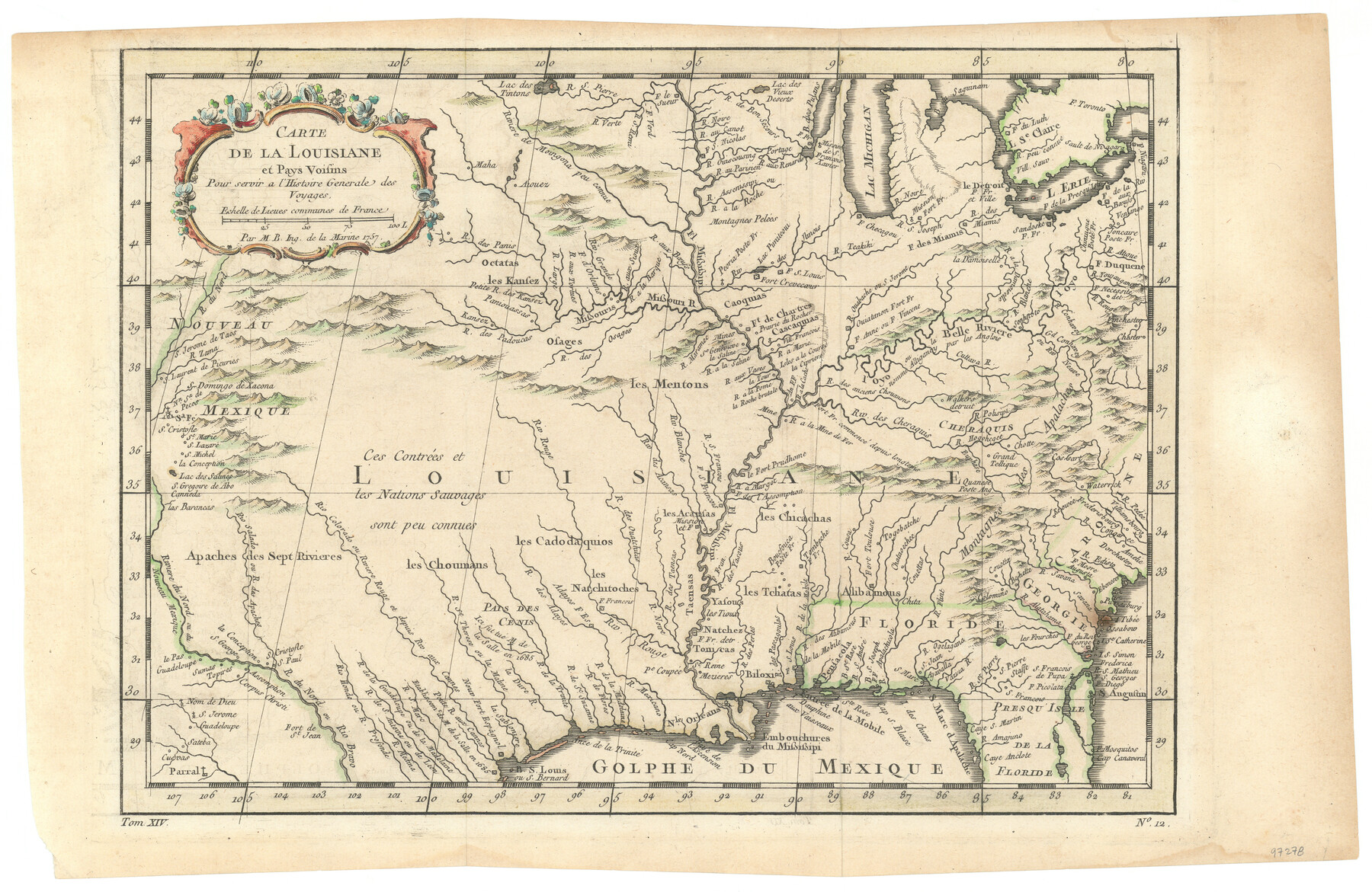
Carte de la Louisiane et Pays Voisins pour servir a l'Histoire Generale des Voyages
Buy Print
$20.00
Buy Digital
$50.00
Please choose a purchase option
$50.00
For-profit publication
Additional + $50.00 fee
Not-for-profit publication
No additional fee
Personal use only
No additional fee
Login to add to favorites
Share on social media
Map/Doc
97278
Collection
General Map Collection
Object Dates
1757 (Creation Date)
People and Organizations
Chase Untermeyer (Donor)
Jacques Nicolas Bellin (Cartographer)
Subjects
North America
Height x Width
10.1 x 15.5 inches
25.7 x 39.4 cm
Comments
Donated by Ambassador Chase Untermeyer in June 2024.
Relief shown pictorially.
From Jean Françoise de la Harpe's Abrégé de l'histoire générale des voyages. 1780.
In lower left margin: "Tom. XIV"; in lower right margin: "No. 12"
Part of:
General Map Collection
View collection
Carousel prev button
Carousel next button
La Salle County
Login to add to favorites
Print $40.00 - Digital $50.00
La Salle County
1923
Size 48.5 x 43.5 inches
Map/Doc 95562
Map of Lee County
Login to add to favorites
Print $20.00 - Digital $50.00
Map of Lee County
1874
Size 22.4 x 18.6 inches
Map/Doc 3805
Map of San Jacinto County
Login to add to favorites
Print $20.00 - Digital $50.00
Map of San Jacinto County
1879
Size 27.0 x 18.1 inches
Map/Doc 4624
Galveston County Rolled Sketch CCW
Login to add to favorites
Print $20.00 - Digital $50.00
Galveston County Rolled Sketch CCW
1938
Size 38.4 x 39.7 inches
Map/Doc 9084
America Settentrionale colle nuove scoperte fin all’anno 1688
Login to add to favorites
Print $20.00 - Digital $50.00
America Settentrionale colle nuove scoperte fin all’anno 1688
1688
Size 29.7 x 37.5 inches
Map/Doc 93709
Cass County Working Sketch 15
Login to add to favorites
Print $20.00 - Digital $50.00
Cass County Working Sketch 15
1957
Size 29.7 x 19.0 inches
Map/Doc 67918
[Capitol Leagues in Oldham County]
Login to add to favorites
Print $20.00 - Digital $50.00
[Capitol Leagues in Oldham County]
1918
Size 37.9 x 30.4 inches
Map/Doc 4506
Zavala County Sketch File 50
Login to add to favorites
Print $10.00 - Digital $50.00
Zavala County Sketch File 50
1956
Size 14.6 x 9.1 inches
Map/Doc 41446
El Paso County Sketch File 28
Login to add to favorites
Print $18.00 - Digital $50.00
El Paso County Sketch File 28
1939
Size 15.2 x 9.5 inches
Map/Doc 22070
Map of Wood County Showing Location of the Texas and Pacific Railway
Login to add to favorites
Print $20.00 - Digital $50.00
Map of Wood County Showing Location of the Texas and Pacific Railway
1872
Size 19.1 x 23.8 inches
Map/Doc 64135
Milam County Rolled Sketch 3A
Login to add to favorites
Print $40.00 - Digital $50.00
Milam County Rolled Sketch 3A
1967
Size 49.5 x 43.3 inches
Map/Doc 9522
Flight Mission No. CRE-3R, Frame 38, Jackson County
Login to add to favorites
Print $20.00 - Digital $50.00
Flight Mission No. CRE-3R, Frame 38, Jackson County
1956
Size 18.6 x 22.2 inches
Map/Doc 85384
You may also like
carousel prev button
carousel next button
Guadalupe County Working Sketch 10
Login to add to favorites
Print $20.00 - Digital $50.00
Guadalupe County Working Sketch 10
1966
Size 21.2 x 27.2 inches
Map/Doc 63319
Kent County Boundary File 4a
Login to add to favorites
Print $18.00 - Digital $50.00
Kent County Boundary File 4a
Size 14.2 x 8.5 inches
Map/Doc 55838
Corpus Christi Pass
Login to add to favorites
Print $20.00 - Digital $50.00
Corpus Christi Pass
Size 45.7 x 41.2 inches
Map/Doc 78454
Hopkins County Sketch File 10a
Login to add to favorites
Print $4.00 - Digital $50.00
Hopkins County Sketch File 10a
1856
Size 12.2 x 7.8 inches
Map/Doc 26702
Webb County Sketch File 12-1
Login to add to favorites
Print $16.00 - Digital $50.00
Webb County Sketch File 12-1
1886
Size 13.0 x 8.3 inches
Map/Doc 39793
Fisher County Working Sketch 14
Login to add to favorites
Print $20.00 - Digital $50.00
Fisher County Working Sketch 14
1957
Size 24.9 x 33.1 inches
Map/Doc 69148
[Sketch of Blks. 2, 2B, 3B]
Login to add to favorites
Print $20.00 - Digital $50.00
[Sketch of Blks. 2, 2B, 3B]
1918
Size 38.0 x 33.2 inches
Map/Doc 89638
Supreme Court of the United States, October Term, 1923, No. 15, Original - The State of Oklahoma, Complainant vs. The State of Texas, Defendant, The United States, Intervener; Report of the Boundary Commissioners
Login to add to favorites
Print $20.00 - Digital $50.00
Supreme Court of the United States, October Term, 1923, No. 15, Original - The State of Oklahoma, Complainant vs. The State of Texas, Defendant, The United States, Intervener; Report of the Boundary Commissioners
1923
Size 35.1 x 41.1 inches
Map/Doc 82996
The Land Offices. No. 8, Mina, December 22, 1836
Login to add to favorites
Print $20.00 - Digital $50.00
The Land Offices. No. 8, Mina, December 22, 1836
2020
Size 10.0 x 10.8 inches
Map/Doc 96421
Travis County Sketch File 11a
Login to add to favorites
Print $4.00 - Digital $50.00
Travis County Sketch File 11a
1873
Size 10.0 x 8.0 inches
Map/Doc 38302
Archer County Working Sketch 10a
Login to add to favorites
Print $20.00 - Digital $50.00
Archer County Working Sketch 10a
1924
Size 25.9 x 40.6 inches
Map/Doc 67150
Crockett County Sketch File 64
Login to add to favorites
Print $20.00 - Digital $50.00
Crockett County Sketch File 64
1927
Size 17.0 x 21.3 inches
Map/Doc 11229
Share via
Facebook
Twitter
Pinterest
Copy Link
Close